


Precinct 120A, Tangipahoa Parish, Louisiana
About
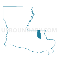
Outline

Summary
| Unique Area Identifier | 590932 |
| Name | Precinct 120A |
| County | Tangipahoa Parish |
| State | Louisiana |
| Area (square miles) | 26.84 |
| Land Area (square miles) | 26.50 |
| Water Area (square miles) | 0.35 |
| % of Land Area | 98.71 |
| % of Water Area | 1.29 |
| Latitude of the Internal Point | 30.57108610 |
| Longtitude of the Internal Point | -90.35911860 |
Maps


Graphs
Select a template below for downloading or customizing gragh for Precinct 120A, Tangipahoa Parish, Louisiana


Neighbors
Neighoring Voting District (by Name) Neighboring Voting District on the Map
- Precinct 118, Tangipahoa Parish, LA
- Precinct 119, Tangipahoa Parish, LA
- Precinct 120, Tangipahoa Parish, LA
- Precinct 120B, Tangipahoa Parish, LA
- Precinct 122, Tangipahoa Parish, LA
- Precinct 123, Tangipahoa Parish, LA
- Precinct 143, Tangipahoa Parish, LA
- Precinct 44, Tangipahoa Parish, LA
Top 10 Neighboring County Subdivision (by Population) Neighboring County Subdivision on the Map
- District 2, Tangipahoa Parish, LA (13,343)
- District 8, Tangipahoa Parish, LA (13,186)
- District 4, Tangipahoa Parish, LA (12,728)
- District 5, Tangipahoa Parish, LA (12,706)
Top 10 Neighboring Unified School District (by Population) Neighboring Unified School District on the Map
Top 10 Neighboring State Legislative District Lower Chamber (by Population) Neighboring State Legislative District Lower Chamber on the Map
- State House District 77, LA (62,319)
- State House District 74, LA (55,721)
- State House District 73, LA (54,461)
- State House District 72, LA (43,119)
Top 10 Neighboring State Legislative District Upper Chamber (by Population) Neighboring State Legislative District Upper Chamber on the Map
Top 10 Neighboring 111th Congressional District (by Population) Neighboring 111th Congressional District on the Map
Top 10 Neighboring Census Tract (by Population) Neighboring Census Tract on the Map
- Census Tract 9537, Tangipahoa Parish, LA (10,368)
- Census Tract 9546, Tangipahoa Parish, LA (10,211)
- Census Tract 9540.02, Tangipahoa Parish, LA (5,716)
- Census Tract 9538, Tangipahoa Parish, LA (4,884)
Top 10 Neighboring 5-Digit ZIP Code Tabulation Area (by Population) Neighboring 5-Digit ZIP Code Tabulation Area on the Map
- 70403, LA (26,011)
- 70401, LA (20,415)
- 70443, LA (10,232)
- 70466, LA (8,512)
- 70446, LA (5,877)
- 70455, LA (1,474)